Does your course have an accurate current as-built of the irrigation system?
More than likely not. It is probably less likely that you have a current and accurate aerial photograph or satellite image.
Nearly anyone associated with the golf course can benefit from an accurate as-built and especially and aerial photograph or satellite image.
Superintendents – For a superintendent an accurate as-built drawing of the irrigation system is critical to the daily and operation, troubleshooting and maintenance of the system. Additionally, the ability to know the accurate area calculations of all the golf course features such as greens, tees, fairways, roughs and bunkers is critical to properly purchase materials and apply fertilizer and chemicals.
General Managers – The aerial photograph can be an extremely valuable tool to the General Manager to help in planning and communicating with the staff, boards and membership.
Golf Professionals – Golf professionals can use the aerial photograph to assist in tournament preparations as well as daily play alerts.
Boards – Boards will find the aerial photos beneficial when they are evaluating the long-range plans and activities of the management staff. they are also every effective in helping explain new projects the club may be soon undertaking or voting upon.
Membership – The membership will find them interesting and beneficial to help know their course better and show to their friends who may be joining them for a round.
Architects – Architects will find them extremely helpful in their long-range planning and design strategy as well the ability to add existing contours.
List of Services
Please review the complete list of ATI GPS Mapping, Satellite imagery Aerial Photography and Contour Mapping services below. Each service is explain in detail later in the blog. Contact the ATI office nearest you for more information and a proposal. It may cot less than you think.
- Aerial Photography and Satellite Imagery Base Map With Area Calculations
- Aerial Photography Combined with GPS of In-Ground Irrigation Components
- Add GPS Mapping of Irrigation and Drainage Points
- Add Mainline and Lateral Piping
- Aerial Photography Contour Mapping
- GPS Green Contour Mapping
The Process
ATI combines Satellite Imagery or Aerial Photography along with GPS mapping to provide the most accurate and visually rich as-built available.
In order for the GPS mapping of the irrigation, drainage or other points such as sprinklers, valves quick couplers and drain inlets to be accurately overlaid on a satellite image requires the satellite imagery or aerial photography to go through a special “orthorectification” process. Orthorectification is a process in which aerial photos are adjusted to correct distortions due to topographic relief, lens distortion, and camera tilt. These geometrical corrections will mean that the scale of the photograph is uniform. Unlike an uncorrected aerial photograph (Google Earth), a orthophotograph can be used to measure true distances, angles and areas. This orthorectification takes the curvature of the earth out of the satellite image and flattens it so the GPS and image accurately match. We have access to such imagery in most areas of the world. The resolution and quality of the photo allows for a very clear picture when zooming as you can see below in the image from a course in Beijing, China. As you can see many different dates and cloud cover percentages can be available.
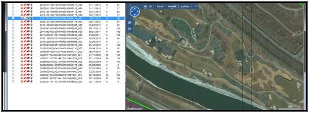
(Chart Indicates Dates of Photos Available and % Cloud Cover)
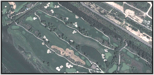
Below is a screen shot from a Google Earth image of the same course in which you can see the distortion of the lens angle, but the curvature distortion is hard to see with the eye but it can be significant.
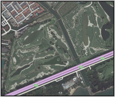
The services are available in a number of ways to meet your budget such as initially providing only the satellite imagery with the area calculations. The irrigation and drainage points can be then added later at any time as funds become available.
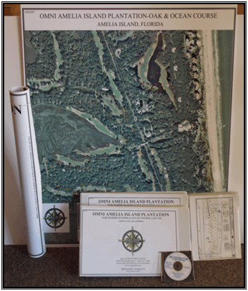
As you can see from the sample, the as-built on high gloss paper offers a high quality as-built great to hang on your wall. The as-built is great for working with your staff, board members and membership. The image can also be incorporated to interface with any manufacturers irrigation software.
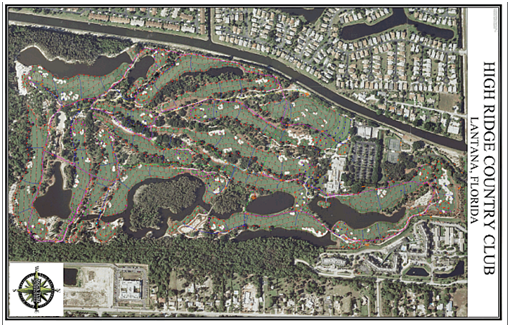
Aerial Photography and Satellite Imagery Base Map With Area Calculations
ATI can provide new high-resolution satellite imagery or a flown aerial photograph of the entire golf course or property depending on your location. The photography will be used to produce a orthorectified image of the site with 0.5’ to 2′ ground pixels. AutoCAD drafting will then be performed on all site features to create a golf course base map. The map will include all the golf course features such as greens, tees, fairways, bunkers, roughs, landscaping plus cart paths, building locations, roads, bridges, driveways, water bodies, railroads, transmission lines, power poles, fences, and grouped tree outlines. A scorecard view of the total area (square feet or meters) of greens, tees, bunkers, roughs and fairways per hole is provided. The as-built drawings will be provided in color on individual sheets at industry standard scales, scaled to fit on a single sheet ready for wall mounting plus 11”x 14” color laminated sheets per hole bound in a book format. The data will also be provided in a digital format.
Option 1 – Irrigation & Drainage Component Point Drafting
ATI provides on site sub-meter precision GPS mapping of the following points:
- Sprinklers
- Mainline Isolation Valves
- Lateral Isolation Valves
- Quick Couplers
- Specialty Valves
- Satellite Locations
- Wire Splices
- Drain Inlets
- Mainline Pipe Routing
Please note that the use of utility vehicle provided by customer. Also, all point locations must be flagged in advance by the customer prior to mapping by ATI. Also, mainline routing must be painted on the ground in advance by the customer prior to GPS mapping.
Option 2 – Irrigation Pipe, Wire and Control Drafting
ATI provides AutoCAD drafting of the following irrigation components:
- Lateral Pipe Routing
- Station Numbers
Please note that GPS data from Option 1 is provided by ATI to the customer for penciling-in of the lateral pipe routing and station numbers prior to drafting.
Aerial Photography and Contour Mapping
Proper land planning and golf course design requires accurate site and contour mapping. ATI can use the aerial photograph base maps or satellite imagery to produce scaled planimetric and topographic mapping with 1 foot, .5 meter or larger contour intervals based on your needs and budget. This will then be used to produce a orthorectified image of the site with a 0.5’ ground pixel. AutoCAD drafting and sophisticated software will be used to create a contour map of the golf course with elevations. All the features of the Aerial Photography Base Map will also be included.
Please note that either aerial photography or satellite imagery requires clear skies and proper scheduling. Make sure you allow adequate time in your planning process to accommodate the process. Additional time may be required depending on your location in the world.
GPS Green Contour Mapping
On some courses it is important during greens renovation to rebuild the green to the exact contours. ATI utilizes precision GPS technology to attain all green topographic information at 1/10th foot contour intervals on putting surface including 5-10’ off the green surface.
Please Note This Service May Not Be Available In All Locations
Deliverables
All drawings will be provided in color on individual sheets at industry standard scales, scaled to fit on a single sheet ready for wall mounting plus 11”x 14” color laminated sheets per hole bound in a book format. The data will also be provided in a digital format.
Contact the ATI office nearest you for more information and a proposal. It may cost less than you think.
